 Russell Fiord Returns
Forest Service Team
of Specialists Continues Work
August 16, 2002
Friday : 12:45 pm
Yakutat, AK - Once again
a water connection has been established between Russell "Lake"
and Disenchantment Bay in the vicinity of the Hubbard Glacier
closure site. In the early
|
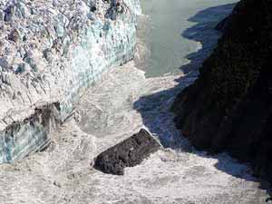
August 14 - Heavy rains raised the
water level in Russell Lake to 61 feet above sea level before
the pressure washed out much of the terminal moraine. This photo
was taken at about noon on August 14th. The day before the channel
ran along the right edge of the opening in the heavy shadow at
the base of the cliff.
(Photo courtesy of the National Park
Service.)
|
hours of August 14th the
channel of water connecting the two bodies of water became a
raging torrent. Observers have hypothesized that the pressure
of rising water in Lake Russell, which registered at over 60
feet above sea level on Tuesday night was sufficient to wash
away 90 percent of the glacier's terminal moraine, composed of
sediment, rocks, and boulders that had served to close off the
water within the lake only hours before. The outwash was rapid
and complete. By noon on the 15th aerial photographs revealed
a 300 foot opening where a closure had been.
Despite the fact that the closure
is a thing of the past this season, Yakutat District Ranger Tricia
O'Connor will continue to work with the team of specialists gathered
to assess potential impacts from long term closure and potential
inundation of the greater Situk watershed. "We continue
to be proactive in our approach to this incident," said
O'Connor. "This team was assembled to take advantage of
the breadth of knowledge from glaciologists, community leaders
and residents of Yakutat, land managers that worked on the last
glacier closure in 1986, and those specialists throughout the
Tongass National Forest and other local, state and federal agencies
that are stakeholders in this event." Incident coordinator
Brian Goettler, an engineer currently stationed at the Forest
Service Regional Office in Juneau, has been hired to coordinate
the team's efforts and work with multiple agency and community
representatives.
Initial efforts concentrated
on getting information out to the Yakutat community, to the general
public, and to recreationists about the conditions in and around
the closure area. Information on the incident is available locally
in Yakutat at the Forest Service District Office
|
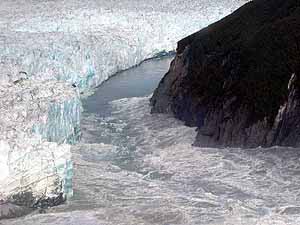
August 14 - About five hours after
the photo at the top was taken, the surging water has removed
the last of the moraine showing at mid-channel and broken off
more of the glacier face. (Photo courtesy of the National Park
Service.)
|
and the Post Office. Information
can be found online on the Tongass Natiional Forest's website.
The web site is updated weekly with news and photographs of the
glacier by scientists and managers using fixed wing planes. District
Ranger O'Connor has been meeting with concerned citizens and
community leaders to discuss the potential socioeconomic effects
of the Hubbard Glacier events and the opportunities for relief
and support they can provide to an area that has experienced
significant economic decline over the last few years. The Forest
Service is leading contingency planning with involved agencies,
including the local city and borough leadership, the US Geological
Survey, the National Park Service, the National Marine Fisheries
Service, the US Fish and Wildlife Service, the US Coast Guard,
and the State Departments of Fish and Game.
Aerial monitoring is the most
cost effective and least hazardous way to monitor the vast area
that includes the Russell Lake basin, and the movement of glacial
ice and sediment and rock in the adjacent moraines. Glaciologists
depend on these multiple aerial views for monitoring the rapidly
changing events at Hubbard Glacier and adjacent glaciers in the
Valerie and Variegated systems. Forest Service and other agency
officials fly over the glacier regularly to assess conditions.
The team members are spending
countless field hours in surveying and ground truthing the micro-topography
and re-establishing monitoring points to examine the rising water
levels
|
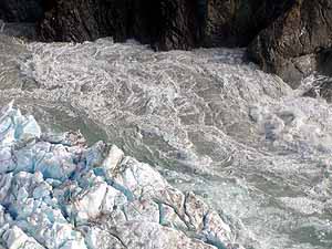
August 14 - Water pouring from Russell
Lake/Fiord creates a dangerous whitewater tumble between glacier
and cliff. This photo was taken at about 5 p.m. (Photo courtesy
of the National Park Service.)
|
in the lake basin and
greater Situk watershed. They are also examining the density
and types of vegetation that may contribute to debris dams that
could divert water as it flows through the greater Situk River
watershed. Soil scientists and hydrologists are examining the
water table in the potentially affected inundation area, as well
as the erosion potential of water that could flow at 10,000 cubic
feet per second (cfs). The current flow in the Situk River is
1200 feet per second. Hydraulic engineers have been working with
the mapping crews to examine the most likely scenarios for the
lake overtopping the basin at the south end, and the potential
routes for that water as it flows towards the sea. Other resource
specialists have been examining infrastructural effects to Forest
Highway 10, culverts, trails and recreational developments that
could be within potential inundation zones.
The US Geological Survey remote
gauging station in the lake shows that the lake level continues
to drop, and is registering water levels within the fiord at
less than 20 feet above mean sea level. Scientists are approaching
predictions with caution regarding whether a more permanent closure
will occur this season or in the near future. Should a stable
ice dam form and the lake level rise to an elevation of about
131 feet, Russell Fiord could drain southward into the Situk
River drainage, altering a world-class fishery, and inundating
national forest and private land, The Situk River is a world-renowned
steelhead and salmon stream and the most productive stream for
its size in Alaska. It is a primary subsistence and commercial
stream, and has a popular sport fishery with many lodges to support
|
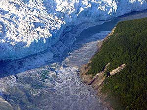
August 14 - The speed of the current
pushes water into the curving face of Hubbard Glacier, where
it bounces back into the turbulent channel. Photo taken about
7 p.m. (Photo courtesy of the US Forest Service)
|
visitation. Because of
the cultural, environmental and economic consequences of Russell
Lake draining into the Situk River, Federal, Tribal, State, and
local officials and citizens are closely following the glacier's
activities.
Current information and photographs
of Hubbard Glacier can be found on the Tongass
Natiional Forest's website and the US
Geological Survey website.
A new Hubbard Hotline has also been installed at the Yakutat
Ranger District Office in the evenings and on weekends at 907-784-3440.
This hotline will contain the most up to date information about
the Hubbard glacier in a short, three minute message. Requests
for further information on Hubbard event may also be left at
the Hubbard Hotline number.
Photo Gallery
Gallery of Hubbard and Glacier Photos
Related Information:
U.S. Coast Guard Information
Safety
Recommendations in Disenchantment Bay
Related Stories:
Hubbard Glacier Approaches Closure of Russell
Fiord...
June 29, 2002
Advancing Glacier Coming Close to Blocking Fiord
Near Yakutat, Alaska...
June 19, 2002
Source of News Release:
USDAFS - Tongass National Forest
Web Site
Post a Comment -------View Comments
Submit an Opinion - Letter
Sitnews
Stories In The News
|